Volcán Masaya National Park
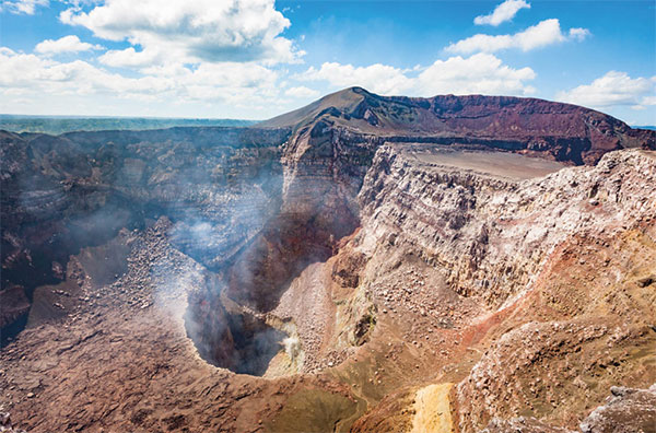
Nicaragua’s first and largest national park, the 54 sq km (34 sq miles) Parque Nacional Volcán Masaya @ [map] is the home of five craters and two calderas. The extremely active Masaya caldera, known as the ‘Gates of Hell’ to the Spanish, exploded as recently as 2001, allowing a new vent to form; ash and steam regularly shoot out into the sky above. While the situation is always changing depending on the level of activity, and the park is often closed to visitors, the standard tour allows for about 30 minutes at the viewpoint overlooking the crater, where steam and bubbling lava can be seen. The road runs nearly to the top of the crater, with the visitor center halfway up, while a network of 20km (12 miles) of hiking trails branches out from it.
Lake Nicaragua and around
Lake Nicaragua, also called Lake Cocibolca, is nearly the same size of South America’s Lake Titicaca, which is why the Spanish nicknamed it the ‘Mar Dulce,’ or Sweet Sea. There are plans to make the lake the centerpiece of a canal project that would rival the one in Panama, likely causing serious environmental degradation, though it might never become a reality. For now, the lake is an ecotourism hotspot, with the island of Ometepe – made of two volcanoes and the narrow strip of land between them – as the focal point. Farther afield is the Solentiname archipelago, an artist colony, and the Rio Coco, which runs parallel to the Costa Rican border and gives access to the Caribbean coast.

The Masaya volcano is highly active.
iStock
Isla de Ometepe
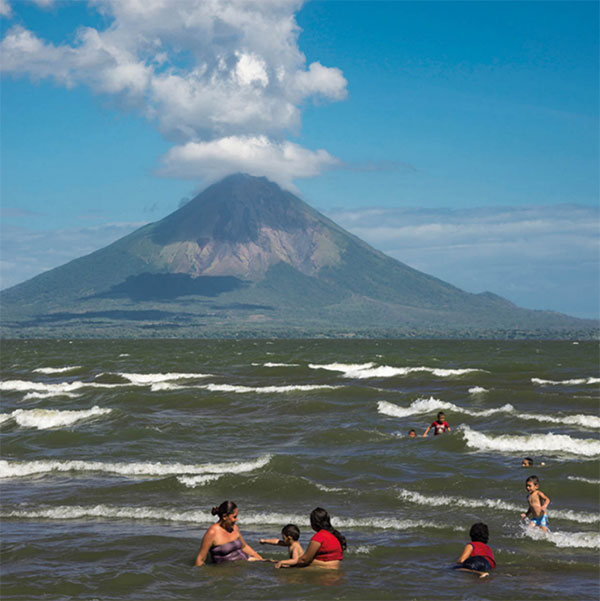
The world’s largest volcanic island within a freshwater lake, Ometepe £ [map] is one of Nicaragua’s primary attractions, even though it’s quite rugged and lacks much infrastructure. Seeing the island’s twin volcanic peaks from the lake – the perfectly conical Concepción and forest covered Madera, connected by the Istián isthmus – is one of the most majestic sights in the country or anywhere else, for that matter. Primarily used for agricultural purposes, nearly anything will grow in Ometepe’s rich volcanic soil, including coffee, bananas, and avocados. Pre-Columbian petroglyphs and rock carvings are found across the island, though there is likely much more to be discovered beneath the thick jungle. Most visitors arrive via the hour-long ferry ride from San Jorge near Rivas, though the airstrip occasionally has flights from Managua.
Moyogalpa and around
With a regular ferry service from San Jorge, Moyogalpa $ [map] is the gateway to Ometepe for most travelers. From the terminal, a road lined with stores, tour agencies, and seafood restaurants runs uphill several blocks to the main ring road that circles the Concepción volcano and the northern half of the island. The largest town on the island and most active, it is rather charming, with a small grid of whitewashed houses with tile roofs and Concepción looming above from every angle.

Isla de Ometepe rises from Lake Nicaragua.
Getty Images
Moyogalpa makes a good base for a hike up the 1,610 meter (5,282ft) high Concepción, with the trailhead 4km (2 miles) north of town at La Concepción. The ascent takes about three hours up and allows for plenty of time to spot monkeys and birds.
Southeast of Moyogalpa is the Reserva Charco Verde, a green lagoon surrounded by jungle and a windy, black sand beach facing the lake. A few simple hotels, a restaurant, and a butterfly farm are just west of the lake.
On the opposite side of the volcano from Moyogalpa is Altagracia, close to where the ferries from Granada dock. The second largest town on Ometepe, it has a small museum with Pre-Colombian ceramics discovered on the island, though it opens at will.
Around Volcán Madera
The southern half of Ometepe, on the isthmus and surrounding the Madera Volcano, is less developed and has more variety in terms of ecotourism. Playas Santo Domingo and Santa Cruz on the eastern side of the isthmus are the best beaches on the island, with black sand and the green jungle creeping up right to the shore. A few rustic hotels and restaurants dot the shoreline.
The road from Santa Cruz to Balgüe, as well as south to San Ramon, has improved dramatically in recent years, opening up the tropical and cloud forests and coffee farms on the northern slopes of Madera to tourists. Several organic and permaculture farms in the area have tourism and/or volunteering projects, including Zopilote (www.ometepezopilote.net), Totoco (www.totoco.com.ni), Finca Magdalena (tel: 84185636), and Café Campestre (www.campestreometepe.com).
San Carlos and around
On the southern eastern shore of Lake Nicaragua, where it meets the San Juan River, San Carlos % [map] is a bustling port town that isn’t much to look at. However, the strategic setting was recognized centuries ago as a place to control a waterway that nearly connects two oceans. After being founded in 1526, the town developed quickly, though pirate attacks and feisty natives upset about rubber tappers encroaching their land kept San Carlos from becoming too powerful.
Most travelers pass through here on their way to the Solentiname Islands, using their time while waiting for boats to hang out at the string of bars and restaurants located in stilted wooden houses over the water. San Carlos has a small, yet impressive, Spanish built fort that dates from 1724 and offers stellar views of the river from a hill above town, as well as a lively waterfront promenade.