THE MENNONITES IN BELIZE
Belize’s Mennonite community is a resilient, religious sect that traces its roots to the 16th century Netherlands. They stand out in any Belizean crowd: blond, blue-eyed men in denim overalls and cowboy hats; modestly dressed women whose home-made outfits – ankle-length, long-sleeved frocks and wide-brimmed hats tied down with black scarves – defy the tropical heat. Polite and reserved, they talk quietly among themselves, not in Spanish, English, or Creole, but in guttural German.
These are part of Belize’s Mennonite community, who take their name from a Dutch priest, Menno Simons. Mennonites live in isolated farming communities, calling themselves die Stillen im Lande, the Unobtrusive Ones. They reject state interference in their affairs and are committed pacifists.
Belize is the latest stop in a three-century odyssey – their beliefs have often led to persecution, driving them from the Netherlands to Prussia in the 1600s, to southern Russia, and, when the Russian government suggested military conscription in the 1870s, to Canada.
After World War I, the Canadian government demanded that only English be taught in Mennonite schools and, spurred on by anti-German feeling, reconsidered conscription. Again, many of the Mennonites moved on, this time to Mexico – only for the Mexican government then to try to include them in a new social security program.
Around 80,000 Mennonites remain in Mexico, including a community in Campeche, but others have moved to Belize, where their farming skills have proved successful. In colonial times few Belizeans farmed the land – even eggs were imported from abroad. The Mennonites are today the most successful farmers in Belize. They supply much of the country’s food, including chicken, dairy products, and eggs, and make most of the country’s furniture.
There is one important rule to remember: strict Mennonites object to having their photographs taken, believing no memory should be left of a person after they die.
Corozal District and Town
Tucked up in the northern limit of Belize, Corozal District looks like it has changed little since colonial days – or, by a further stretch of the imagination, the days of the Maya. The district is still only sparsely populated and scattered with small, sleepy villages. Its entire eastern half is swampy savannah, accessible only by an uneven road that roughly traces the New River and Freshwater Creek; the western coast is dominated by sugar cane and is one of the most intensely cultivated agricultural areas in the country.
Fact
The name Corozal comes from the cohune, a large palm that likes fertile soil and was a symbol of fecundity to the Maya (its name is thought to come from the Spanish cojones, meaning testicles, after the tree’s round nuts).
The district’s urban hub, Corozal Town * [map] , overlooks Chetumal Bay. A sea wall winds its way around the edge of town, and you’ll often see the locals splashing in the waters here.
For an overview on Corozal and the region, head to the Corozal House of Culture (1st Avenue; Mon–Fri 8am–5pm), housed in a renovated market dating back to 1886. The well-curated museum features a wide range of exhibits, including local art and Maya artifacts.

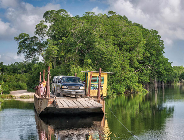
Cable ferry crossing New River on the way from Corozal Town to Copper Bank.
Alamy
Sarteneja and Shipstern Nature Reserve
The name of Sarteneja ( [map] , a lazy fishing village on the Sarteneja Peninsula, means ‘hole in a flat rock,’ referring to a cenote or well. This must have been an attraction to the ancient Maya in this low rainfall district, with levels of precipitation well below the rest of Belize. Sarteneja is a pleasant enough place to pass an afternoon. The buildings’ pastel colors are drained by the fierce sun, and you can go swimming right off the main pier in waters that range from milky to clear.
Just outside Sarteneja – and the main reason for coming to this remote corner – is the Shipstern Conservation & Management Area (daily 8am–5pm), founded in 1988. The reserve features an extensive, shallow, brackish water lagoon system, home to breeding colonies of many varieties of birds like the reddish egret and the wood stork.
Western Belize
When travelers talk about visiting the interior of Belize, they are usually referring to the lush, mountainous rainforests around the town of San Ignacio, long the heart of the country’s ecotourism trade. The region is a nature-lover’s fantasy come true. Spread out across a remote subtropical wilderness are dozens of cabaña-style lodges, many of them quite luxurious. Within striking distance – by car, horseback, canoe, or foot – are secluded, jungle-rimmed swimming holes, enormous limestone caverns, Belize’s most significant Maya ruins and Central America’s highest waterfalls. The background music is the shriek of tropical birds, while iguanas, gibnuts, and skunks habitually stroll across the well-marked nature trails.
Meanwhile, the rainforests are surprisingly free of Belize’s least popular life form, the mosquito – the higher altitude makes days around San Ignacio hot without being overwhelming, while evenings can almost be described as cool.
On the frontier with Guatemala, this is also one of the more Hispanic parts of Belize, populated largely by Spanish-speaking mestizos, and Maya farmers; second in numbers come creoles, followed by a classically Belizean smattering of East Indians, Chinese, and Lebanese. Several large communities of Mennonites farm the rich land and can be seen clattering along the highways in horse-drawn buggies.
Across the Belizean western border in Guatemala lie the remains of one of the most magnificent ancient cities anywhere in Central America – Tikal (for more information, click here). A wide variety of tourist companies offer trips to Tikal from Belize; inquire at your hotel, which can often supply a list of recommended outfitters. Note that Crystal Auto Rental (for more information, click here) is one of the few car rental companies that allow you to take their vehicles across the border.