THE COSTUMES OF GUATEMALA
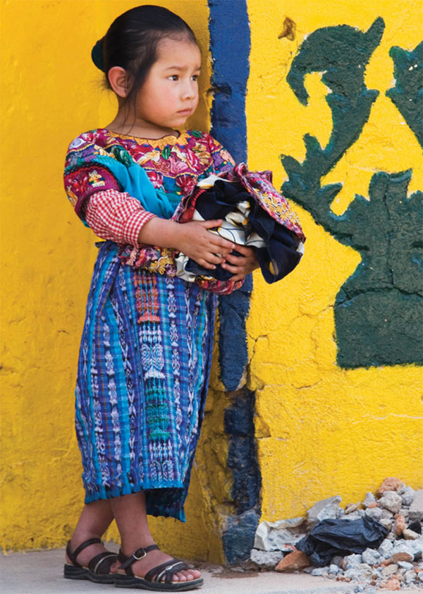
The Maya today identify with their villages rather than with their ancestral tribes, although the languages they speak still conform to the pattern of ancient tribal boundaries. Marriages between members of different communities are relatively rare, and village identity is consolidated further by the distinctive clothes worn by the women and some men.
Costumes fall into three categories: everyday dress; more elaborate wear for special occasions; and the ceremonial garments worn by the cofradías. Although colors, designs, and the way of wearing particular garments differ from village to village, all women’s apparel consists of the same basic articles: a huipil (a loose rectangular blouse), a skirt, sash, hair-ribbon, and tzut (multi-purpose carrying cloth) or shawl. Each item is hand-woven, either on a simple hip-strap loom or a foot-loom.
Men’s traditional costumes have been preserved in only a few villages, most notably in those around Lake Atitlán, and in the mountains of Huehuetenango. You can recognize Maya men from Lake Atitlán by their striped pants decorated with village motifs and held up by sashes; sometimes a length of woolen fabric is wrapped around the hips too. Black split over-pants are used in Todos Santos and by Sololá officials, whilst the men of San Juan Atitlán wear woolen capixays that resemble the cassocks used by the Spanish friars.
The heart of the city, the sprawling Parque Centroamérica holds an impressive assortment of buildings, including the Municipalidad (city hall), the cathedral, and, in the center of the square, a strange visual cocktail of neo-Grecian columns and stone benches. The Catedral (generally daily) is a modern concrete building, with only the facade remaining of the original. The Bishop of the Highlands, an important post, is stationed here. Inside the cathedral is an image of El Padre Eterno (The Eternal Father) housed in a silver case. The La Casa de la Cultura (hours vary, generally Mon–Fri 8am–noon, 2–6pm, Sat 9am–1pm) on the south of the square, features a variety of museums, including the Museo de Historia Natural where there’s an assortment of pre-Columbian artifacts, and the Museo de Arte, with changing exhibits of local art.
The Museo del Ferrocarril focuses on the railroad that connected the city to the Pacific Coast. Next door, in the same building, Museo Ixkik’ covers Maya costume from the highlands. Both museums were closed for renovations at the time of writing.

Girl in traditional costume, San Andrés Xecul.
Corrie Wingate/Apa Publications
The Teatro Municipal, north of the park, is a solid neo-colonial edifice. The theater faces a plaza, which contains various busts of local artists, including Guatemala’s first Poet Laureate, Osmundo Arriola (1886–1958).
Around Quetzaltenango
The village of San Francisco El Alto % [map] hosts one of the biggest markets in the Maya region. The Friday morning market is a wonderful spectacle and a real assault on the senses, as thousands of traders descend on the small village to buy and trade everything from honking hogs to fine fabrics. Textiles are bought here to be sold around the country, and some good bargains can be found here and in the town’s many textile shops.
Around 19km (12 miles) from San Francisco is the popular market town of Momostenango ^ [map] , specializing in chamarras (warm, woolen blankets) and carpets. Some good-quality textiles can be bought here, especially at its twice-weekly markets on Wednesday and Sunday. Momostenango is also a center for Maya religious study, with many shamans working here, attracting students from all over Guatemala.
Fact
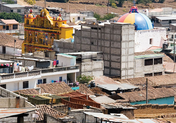
San Andrés Xecul, about 8km (5 miles) to the northeast of Quetzaltenango, has a stunningly colorful church that is claimed to be the oldest in Central America (although the color scheme is 20th-century). The background color is yellow, decorated with brightly dressed angels and vines, while the dome resembles a stripy beach ball.
The Cuchumatanes
In the far west of the country, the highland scenery becomes even more dramatic, dominated by the blunted peaks of the Cuchumatanes mountains. Above Huehuetenango there’s a huge high-altitude plateau known as the altiplano, a dauntingly inhospitable environment where trees are stunted by the cold and little else will grow.
The Cuchumatanes have always been an isolated region, which helped shield the overwhelmingly Maya inhabitants from changes that have affected villages closer to the Interamericana. In many villages, the Maya Haab and Tzolkin calendars are still observed by prayer keepers. Travel in the mountains is tough, hotels and restaurants are simple, but the spellbinding scenery is ample compensation.

The church in San Andrés Xecul.
Corrie Wingate/Apa Publications
Huehuetenango
The pleasant town of Huehuetenango & [map] is both a transportation hub and a departmental capital. The main sight, however, is Zaculeu, Maya ruins 5km (3 miles) from the center of ‘Huehue.’ Zaculeu was the capital of the Mam nation, one of the main tribes that confronted the Spanish. The former capital, like the other highland Maya centers, was well fortified, and the Mam held out for six weeks before they surrendered.