Montecristo National Park
Northeast of the country town of Metapán is the cloud forest-covered national park of Montecristo ) [map] , which straddles the border with Honduras (where it is known as Montecristo-Trifinio National Park). Within the humid park are giant ferns, lichens and mosses that provide cover for spider monkeys and anteaters. Cypresses, oaks, and pines can reach up to 30 meters (98ft) in height, attracting nearly 300 bird species, including green toucans and white-faced quails that are rarely seen in other parts of the country. Basic trails intersect the park and a four-wheel-drive vehicle is necessary to reach the entrance. Within the park are several attractions, such as an orchid garden and a museum (both daily) with a collection of oddities inside an historic hacienda. It’s best to visit the park during the dry season from December to April.
Eastern El Salvador
Off the radar for most visitors, this rural, undeveloped region with its hodgepodge of cattle farms and sugarcane plantations is for many the real El Salvador. Eastern El Salvador is noticeably poorer than the west and saw some of the most brutal incidents of the civil war. As the scars continue to heal, the region is opening up, with friendly, country towns planting themselves firmly on the tourist trail.

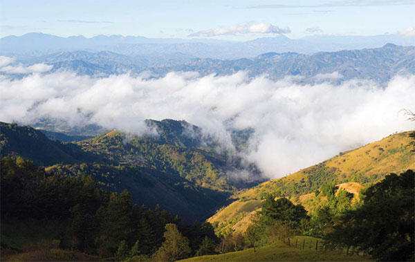
Cloud-shrouded valley below Cerro El Pital.
Alamy
Alegría
Between San Salvador and San Miguel, the hilltop town of Alegría is considered the flower capital of El Salvador. The cooler climate at 1,200m (3,937 ft) above sea level affords the village sweeping views of the surrounding countryside and coffee plantations. Activity centers around the town square, where a kiosk can help arrange tours to a crater lake and plantations, as well as map out the hundreds of flowers displays in town.
San Miguel
The largest city in the eastern half of El Salvador is traffic-clogged and chaotic, with high crime and crowded marketplaces. However, just when you think there is nothing to see in San Miguel ! [map] , founded in 1530, you come face to face with some of the finest colonial architecture in the country, seemingly lost within the disorder. On the main plaza, the Catedral Nuestra Señora de La Paz (daily), which dates to the 18th century, and the mustard yellow, neoclassical Teatro Nacional (Mon–Sat), which has a storied history as a silent film movie theater and later a hospital. A small museum, the Museo Regional de Oriente, is attached, exhibiting pre-Colombian to modern-day collections of artifacts once used by Indigenous communities.
Eight kilometers (5 miles) west of San Miguel, just off the Pan-American Highway, is the archeological site of Quelepa, a Lenca site with several dozen ceremonial platforms that are mostly unexcavated.
Roughly 40km (24 miles) to the southeast is the Laguna de Olomega, where you can arrange trips with local fisherman around the lake and to Los Cerritos Island.

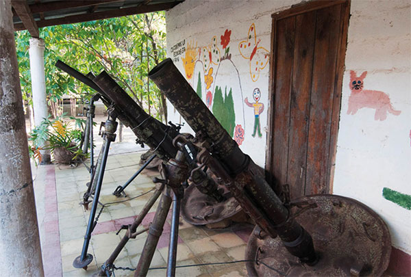
Mortars at the Museo de la Revolución Salvadoreña in Perquin.
Getty Images
Perquín
In the mountainous, forested Morazán region 53km (33 miles) north of San Miguel near the Guatemalan border, Perquín @ [map] was the headquarters for the FMLN. There are a few small artisan shops around the plaza, but the main attraction here is the Museo de la Revolución Salvadoreña (daily 8am–5pm), which recounts the guerrilla movement with pride through artifacts and photos. One of the highlights is a recreation of Radio Venceremos, an opposition radio station that was broadcast throughout the country during the 1980s and is now a commercial radio station (la RV).
North of San Miguel
The community of Cacaopera, about 9km (6 miles) east of Delicias de Concepción, is something of a mystery. The village’s residents are believed to be the very last of the Ulua ethnic group, which linguistic evidence points to having originated south of El Salvador. The residents still cling to their ways of farming, architecture and clothing, which is detailed briefly in a small ethnographic museum.
One of the most infamous moments of the civil war occurred in the village of El Mozote, 8km (5 miles) south of Perquín. On December 11 and 12, 1981 the army rounded up nearly 1,000 people from the village around the square and church, many of them children, and executed them. Much of the town was burned after and the massacre was kept hidden for years. The United Nations truth commission formally recognized the incident in 1992 when the bodies were excavated, drawing international condemnation. Today, guides in town show visitors a memorial on the plaza where the names of those who died are written.
La Unión and around
Founded as Puerto San Carlos, the grimy port town of La Unión £ [map] is little more than a transit hub for those en route to Honduras or to explore the beaches and islands in the Gulf of Fonseca. While there are a few interesting colonial buildings in the city, there’s little reason to make an extended stop here.
Along the coast southwest of town, beyond the Conchagua Forest, is a string of unspoiled beaches, many of which rarely see any visitors outside of the occasional surfer. The first pair of beaches, moving east to west along CA-2 are Playa Jaguey and Playa El Tamarindo. There are few amenities and private homes take up much of the beachfront.
A few kilometers west, Playa Esteron and neighboring Playa El Cuco have the most to offer. Many weekenders from San Miguel come here regularly and there are plenty of small restaurants and hotels scattered out along the wide beachfront. The best hotels are closer to El Cuco, such as the upscale 15-room Las Flores Resort (www.lasfloresresort.com), designed by Salvadorian architect Rodrigo Barraza Dominguez and taking up 2.8 hectares (7 acres) of beachfront, and the more laid back Las Olas Surf Resort (www.lasolassurfresort.com). The surf is good here, and for much of the year pros gather near Las Flores and Punta Mango.