Manuel Antonio National Park
Once an important banana-shipping port, Quepos ™ [map] is now something of a dormitory town and business center for Manuel Antonio, 7km (4 miles) away. There are some good accommodations, restaurants, shops, banks, and nightlife, a regular bus service, and the flavor of an old-time fishing and banana town. The sport fishing here is excellent. Hotel reservations are essential during the vacation season at both Manuel Antonio and Quepos.
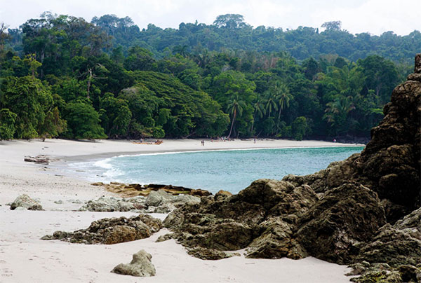
The Parque Nacional Manuel Antonio # [map] (manuelantoniopark.com/; Tue–Sun 7am–4pm) encompasses three long strands of magnificent white sand, fringed by jungle and the Pacific Ocean, along with 7 sq km (3 sq miles) of forest. The beaches are clean and wide. Above them are tall cliffs covered in thick jungle vegetation. This park is one of the few places in the country where the primary forest comes down to the water’s edge in places, sometimes allowing bathers to swim in the shade. In order to protect the ecosystem of the park, rangers allow a daily maximum of 600 visitors on weekdays and 800 on weekends.

Playa Manuel Antonio is accessible via a hike.
Corrie Wingate/Apa Publications
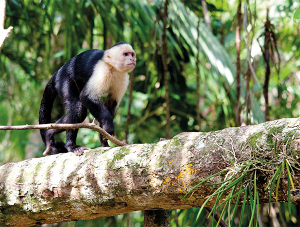
Playa Espadilla is the very popular public beach just outside the north end of the park. It is beautiful but it has unpredictable riptides. From Playa Espadilla, you enter the park across an estuary, which at high tide often requires a boat ride. To get to Playa Espadilla Sur, the first beach in the park, follow the jungle path across a long sandspit called a tombolo. Playa Manuel Antonio and Playa Puerto Escondido require more hiking but the latter, accessible only at low tide, is less crowded. There are excellent trails for hiking and wildlife sighting. Keep an eye out for all four of Costa Rica’s monkey species – the aggressive, white-faced (or capuchin) monkeys that may steal your picnic (or bite you, so don’t feed them); the larger, acrobatic spider monkeys (colorados) that keep their distance; the sedentary leaf-eating howler monkeys (mono congo); and the tiny squirrel monkeys (titís) that tumble through the treetops. Birdlife encompasses more than 350 species, including boobies, frigate birds, pelicans, and terns.
Just outside the park to the north, in the hills that rise up from the beach, there is a garish profusion of signs advertising an ever-growing number of hotels, restaurants, and cabinas. One of the best views is from Hotel Sí Como No (www.sicomono.com), a luxury eco-hotel that has won international prizes for its sustainability in both design and services.
Southern Costa Rica and Península de Osa
The Zona Sur, or Southern Zone, rises in the highlands around Cerro de la Muerte, the highest point in the country, then falls away into the agricultural lands of the Valle de El General and ends in the tropical lowlands at the Panamanian border. This is an unbeatable destination for hikers and nature-lovers with a sense of adventure, who like exploring off the beaten path. Jutting out more than 50km (30 miles) into the Pacific, the Osa Peninsula shelters the Golfo Dulce from ocean swells and creates a magnificent natural harbor. It is sculpted with picturesque beaches and rocky headlands, and dissected by streams and rivers that cascade over volcanic cliffs on their way to the sea. The most majestic forests in all of Costa Rica cover the hillsides and line the valleys of the Osa Peninsula and, in many cases, represent the last stronghold of nature and endangered animals and plants, endemic to the South Pacific. The most famous attraction is Corcovado National Park, the jewel in the crown of Costa Rica’s national park system.
Drake Bay
On the northern coast of the Osa Peninsula, Bahía Drake ¢ [map] is reputedly where Sir Francis Drake, the first English navigator to sail around the world, landed in 1579. Until recently, this outpost, surrounded by crystal-blue waters, pristine beaches, and jungle, was accessible only on foot, by water or by charter plane. Now there is a dirt road from Rincón, built by the national power company to bring electricity to the village, as well as direct flights from San José to the Drake airstrip. A trio of upscale lodges in Drake Bay tops the wide choice of accommodations. The most romantic is La Paloma Lodge (www.lapalomalodge.com), built on a breezy bluff with sweeping views of the ocean; its elegant and comfortable cabinas, with thatched roofs and private decks, blend unobtrusively into the jungle environs. Just south of Drake Bay village, the Coastal Footpath begins. This easy-to-walk scenic trail cuts between dense jungle on the landward side and crashing surf on the Pacific side. There are also calmer sandy coves along the way. The path leads south all the way to Punta Marenco Lodge (www.lodgepuntamarenco.com), in the 500-hectare (1,200-acre) Refugio Nacional de Vida Silvestre Río Claro.

White-faced capuchin monkey in Parque Nacional Manuel Antonio.
Corrie Wingate/Apa Publications
Isla del Caño
The Isla del Caño ∞ [map] biological reserve sits low on the horizon, about 19km (12 miles) seaward of the Corcovado coastline, a pleasant one-hour boat ride from either Marenco or Bahía Drake. Spotted dolphins ride the boat’s bow wave, and flying fish sometimes escort boats to the island. Between December and April, 40-ton humpback whales come from their feeding grounds in Alaska. The island is ringed with turquoise water, tiny beaches, and acres of coral-covered rock reefs. Brilliantly colored tropical fish are easily seen by snorkelers and scuba divers within 15 meters (50ft) of the shore at the park headquarters. Steep, well-manicured trails lead through a rich forest drooping with epiphytes and enormous philodendrons to a clearing with ancient stone spheres. Thousands of spheres like this have been found in the south of Costa Rica, and a few also in northern Panamá. They pose one of the country’s great riddles. Though their exact origin and significance have defied explanation, it is speculated that they were made in villages on the Osa Peninsula near Palmar Norte, brought to Caño in canoes, and then possibly rolled to the cemetery at the highest point of the island. The best place to see las bolas, as they’re locally known, is the Finca 6 Archeological Site (Tue–Sun 8am–4pm), 6km (4 miles) south of Palmar Sur, where the stones can be seen in their natural surroundings. A small museum has displays exploring the history and significance of these baffling spheres.