Fact
The city of Managua straddles several fault lines that experiences major seismic activity every 50 years or so. The last major quake occurred in 1972, which destroyed large swathes of the city center and displaced two thirds of the population. A 5.6 magnitude quake and its aftershocks hit in 2014, destroying roughly 2,000 houses, but it’s only a matter of time before a bigger quake hits.
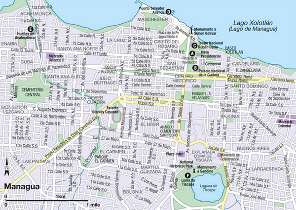
Managua’s center is the Plaza de la Revolución A [map] , with its 1933 monument honoring the Nicaraguan poet Rubén Darío. The Catedral Vieja, or at least what is left of it, is less than a block to the east. While the church, which dates from 1929, is too fragile to enter, visitors can still glimpse at the frescoes and statues inside. To the south, attached to the National Library, is the Palacio Nacional de la Cultura B [map] (www.inc.gob.in; Mon–Fri 8am–5pm, Sat 9am–4pm, Sun 10am–5pm), where Sandinista rebels staged a hostage siege in 1978, resulting in the release of political prisoners. Today the building is home to the National Museum, with a collection of Pre-Columbian ceramics and artifacts, as well as various pieces and displays from the revolution.
Built in 1969, the Teatro Nacional Rubén Darío C [map] , to the north of the plaza near the malecón (pier), was one of the few buildings to survive the 1972 earthquake and continues to be an integral part of Managua culture with regular dance exhibitions and concerts.
The sprawling lakefront complex in the old port area, Puerto Salvador Allende D [map] , stretches for several kilometers and is lined with restaurants, playgrounds and beach access. Opened in 2008, it has quickly become the preeminent tourist attraction in Managua. There is live music and roving performers on the weekends, and boat trips to the Island of Love.
Discovered by miners in 1874, the Huellas de Acahualinca E [map] are the fossilized tracks on the shore of Lake Xolotián of a small group of people, as well as various animals and birds that date back an estimated 6,000 years. It’s believed that volcanic ash covered the footprints, perfectly preserving them. There is a small site museum (Mon–Fri), with an exhibition of Pre-Columbian ceramics. It’s in a rough neighborhood near the Mercado Oriental, so it’s best to take a taxi in and out.

A national historic park southeast of the center on the edge of Volcán Tiscapa, Loma de Tiscapa F [map] , looks out over a small crater lake and is home to Managua’s most recognizable landmark, a statue of revolutionary hero Augusto Sandino. The site was once the home of Somoza’s presidential palace; it’s now home to a collection of Sandinista monuments, such as a tank donated by Mussolini. There are stunning views of the lake and center, as well as a canopy tour.
Outside of Managua
The 184-hectare natural preserve of Chocoyero-El Brujo, 23km (14 miles) south of Managua, protects one of Managua’s primary water sources. Dissected by a network of hiking trails, the park contains two waterfalls, El Brujo and Chocoyo, both around 25 meters (82ft) in length. At around 3pm each day, flocks of chocoyos, a variety of the Pacific green parakeet, can be seen flying around the cliffs of the canyon near the Chocoyo falls. Also within the lush green park are toucans, two types of monkeys, and other small mammals.
In the town of Tipitapa, about 22km (16 miles) east of Managua along the shore of the lake, you will find the El Trapiche hot springs, a basic thermal pool overlooking the Tipitapa River.
Northern Nicaragua
Despite being well removed from the tourist trail, the mountainous northern half of Nicaragua has some of the country’s most interesting attractions. Dotted with patches of picturesque farmland and cloud forest dripping with waterfalls in the east, and volcanoes and hot lowlands toward the Pacific, waves of colonists, from pirates to the Spanish to revolutionaries, have all made their mark here.
For much of the past century the region has been plagued with wars and natural disasters. The turbulence began in the early days of Spanish settlement, when a volcanic eruption destroyed the original setting for León; emerged in the conflicts of the 1930s, when General Sandino battled American marines; continued with the Sandinista struggle in the 1970s; the Contras a decade later; and culminated with Hurricane Mitch in 1998, which left countless towns devastated.
Today the north is one of the most industrious parts of the country as the setting for coffee farms around Matagalpa and the tobacco plantations near Estelí. There’s also cycling through the pine-filled valley that surrounds the colonial town of Ocotal, and hiking through the gorges outside of Jinotega. More of a DIY Nicaragua than Granada or the Pacific coast, the north is full of authentic rural character.