LAND OF FIRE
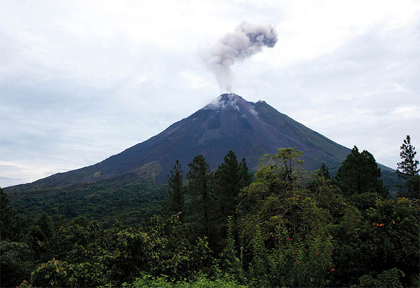
Until early July 1968, Arenal was a heavily wooded low hill, similar to many others in the area, near the village of La Fortuna. One morning local people began feeling a few earth tremors. Suddenly, the forest started smoking and steaming. Women washing their clothes marveled at the sudden warm water that flowed in the creeks. Then, on July 29, Volcán Arenal exploded. Rolling clouds of gas and fountains of red-hot boulders and molten lava hit the countryside. Official estimates put the death toll at 62, but local people claim that more than 80 people were killed. More than 5 sq km (2 sq miles) of land near the volcano was abruptly changed from pastoral farmland to a landscape out of Dante’s Inferno. Arenal remained continuously active from then until October, 2010, when it just as suddenly stopped spewing and spitting out fiery rocks. In 2013 it awoke again to send a column of steam high into the air. The Arenal is officially still active, but in a ‘resting phase,’ and no one can predict its next move. Even without the pyrotechnics, Arenal is still everyone’s preconception of a volcano: conical, rising abruptly out of flatland vegetation. But do not attempt to climb the upper reaches. Although it’s in a resting phase, the volcano still occasionally belches dangerous gases. A sign at the base of Arenal Volcano reads ‘Volcano influence area. If you notice abnormal activity, run away from the area and report it to the nearest authority.’
Oasis Nature Tours (www.oasisnaturetours.com) organizes both kinds of river trips.
Rara Avis Rainforest Lodge (tel: 2764 1111) is a pristine, 600-hectare (1,500-acre) rainforest preserve adjacent to Braulio Carrillo National Park. Established in 1983, it was Costa Rica’s first ecolodge. The main office and departure point for the reserve is in Las Horquetas, a village 17km (11 miles) south of Puerto Viejo de Sarapiquí.
Guanacaste
The province of Guanacaste includes both the northern part of the Nicoya Peninsula, attached to the mainland, and a huge tract of mainland set between mountains draped in cloud forest and the Pacific Ocean. This is Costa Rica’s Big Country, where vast grasslands are punctuated by huge spreading guanacaste trees and bony, white Brahman cattle. During the rainy season, the landscape is a sea of green, but in the dry season, the savannahs become sun-baked tracts of gold. Traditionally cattle country, Guanacaste is better known nowadays as the gateway to controversially large hotel resorts for sun-starved visitors who arrive at Daniel Oduber International Airport south of the province’s capital, Liberia, by the thousands. Overdevelopment in some areas has even engendered a new word: Guanacasteficación, signifying unsustainable development.
Liberia
The capital city of Guanacaste province, Liberia ‚ [map] was established more than 200 years ago. It is also known as Ciudad Blanca, the White City, owing to the traditional whitewashed adobe houses, built in the Puertas del Sol – ‘Doorways of the Sun’ – style, designed to let both morning and afternoon sunlight into north-facing corner houses. A few of these lovely old adobe homes can still be seen along the city’s narrow streets. The easiest way to get a first-hand look at one of these grand houses is to drop into the Café Liberia on Calle Real. It’s an excellent café/restaurant in a beautifully-restored mansion with painted cupids cavorting amongst flowers on the ceiling mural in the main dining room, and a garden courtyard that doubles as an art gallery.
Rincón de la Vieja National Park
About 5km (3 miles) north of Liberia along the Interamericana Highway, you will reach the turnoff for Parque Nacional Rincón de la Vieja ⁄ [map] (www.acguanacaste.ac.cr/turismo/sector-pailas; Tue–Sun 7am–3pm). This spectacular park contains two towering volcanic peaks, the slightly higher one reaching a height of 1,916 meters (6,286ft), plus four complete ecosystems within its 14,000 hectares (35,000 acres). The name, which applies to both the park and the volcano it protects, derives from the legend of an old woman who once lived on its slopes. The volcano is intermittently quite active now and some hiking trails are off limits, owing to noxious gas emissions. Check current conditions with the park office before heading to the park.
All visitors to the park must pay for their entry tickets in advance through the SINAC website (www.serviciosenlinea.sinac.go.cr/). Then, on arrival at the Las Pailas ranger station, you sign in and pick up a map of the park and the hiking trails. Just steps away is the park’s most spectacular volcanic area, Las Pailas, Spanish for ‘the kitchen stoves.’ There is a well-marked, 3km (2-mile) self-guided loop tour of hot springs, boiling mud pots, sulfur streams, and vapor geysers that color the surrounding rocks red, green, and vivid yellow.
The two closest lodges to the park are Rincón de la Vieja Lodge, a collection of rustic cabins and comfortable bungalows; and Hacienda Guachipelín (www.guachipelin.com), a working ranch turned upscale lodge, with first-rate horses and many kilometers of hiking and birding trails and adventure activities, including canopy tours and river tubing.

Arenal volcano spews steam.
Corrie Wingate/Apa Publications
Peninsula de Nicoya
By far, the most popular beach destinations in Costa Rica cluster round the shores of the Nicoya Peninsula. The outer, western beaches rim the Pacific coast, while the inner beaches face the Gulf of Nicoya. This boot-shaped peninsula straddles two provinces: the northern part branches out from the Guanacaste mainland, then morphs into Puntarenas province in the south. In the days before there were any roads on most of the peninsula, the mainly coastal communities were accessible only by boat from the nearest port, Puntarenas. So, rather anachronistically, the Nicoya Peninsula remains part of Puntarenas province today.