Lamanai
The trip to Lamanai @ [map] (daily 8am−5pm) is often as memorable as the impressive ruins themselves, thanks to the adventurous journey required to get there, via a rugged dirt road or a dreamy river trip through the sinuous waterways of a remote jungle river. Located on the banks of the New River Lagoon, it can be reached by easy day trips from Orange Walk. In addition, numerous tour companies offer trips to Lamanai from Belize City and the Cayes.
The river and surrounding swamp is teeming with wildlife, including a healthy population of Morelet’s crocodiles. These gave Lamanai its name – Maya for ‘submerged crocodile’ – and make the prospect of swimming, while safe, rather nerve-racking. Apart from pointing out birdlife, most boat drivers will bump up against gutted tree trunks on the shoreline, waking up a mass of tiny, sleeping bats, and sending them in a cloud over passengers’ heads.
By the time you reach the ruins, you feel like Indiana Jones, and since you may well have the place to yourself, there’s nobody to destroy the illusion. A few thatched-roofed houses have been built at the dockside for the ruin’s guards, along with an open-air picnic hut and a small museum piled high with Maya artifacts.
Lamanai was first settled some 3,000 years ago and its most impressive temples were built in the Preclassic period around 100 BC. Several centuries later, in the Classic period, the population had increased from 20,000 to 50,000. What makes Lamanai unique is that it was still inhabited when the first Spanish conquistadors arrived in search of gold here in the 16th century. The population was about a quarter of what it had once been and its most spectacular temples were untended. How Lamanai survived the cataclysm that devastated the other Maya cities is unknown. In any case, Spanish missionaries quickly set about building a church to convert the heathens. The Maya rebelled and burned it in the 1640s, but European-imported diseases soon decimated the community. Even so, there were a few Maya inhabitants here when British settlers arrived in the 19th century; the new colonialists drove them out to Guatemala so the land could be cleared for sugar.
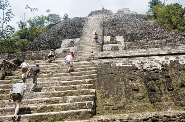
Lamanai’s best-known and most impressive pyramid is N10-43, a steep, 34-meter (112ft) high edifice. It reached its present height by around 100 BC, making it the largest Preclassic structure in the whole of Mesoamerica (although not as tall as the Classic pyramids at Xunantunich and Caracol, it is still considerably higher than any modern Belizean building). Like most Maya structures, it was modified heavily.
If you’d like to stay near the ruins, one of the best spots is the Lamanai Outpost Lodge (www.lamanai.com), which has thatched cabanas with private decks and a lagoon-facing restaurant that serves excellent local cuisine.
Orange Walk
Forming the hub of northern Belize’s main roads, Orange Walk £ [map] is still the most convenient, if not the most interesting or comfortable, base for exploring the north. Although this is the largest town in the north, it’s a dusty, quiet place, with just a handful of sights. The Banquitas House of Culture (www.facebook.com/Banquitas; Mon–Fri 8.30am–5.30pm), a small museum and cultural center just north of the town, has exhibits on the history of Orange Walk and the logwood industry, and some Maya artifacts on display.

Climbing the high temple at Lamanai.
Corrie Wingate/Apa Publications
Orange Walk is fondly called ‘Sugar City’ by residents because it is smack in the center of the northern sugar industry. Orange Walk has a variety of breezy, inviting accommodations, including El Gran Mestizo Riverside Cabins (www.elgranmestizo.bz), which also feature one of the town’s best restaurants, Maracas Bar & Grill, where you can feast on shrimp ceviche and tropical cocktails while looking out at the New River.
While it may not have the mass appeal of Lamanai, the Cuello archeological site on the property of the Cuello rum distillery, some 5km (3 miles) to the west of Orange Walk, is believed to be the oldest Maya ceremonial site in the area, dating back some 2,600 years. Permission must be obtained from the distillery to go onto the property.
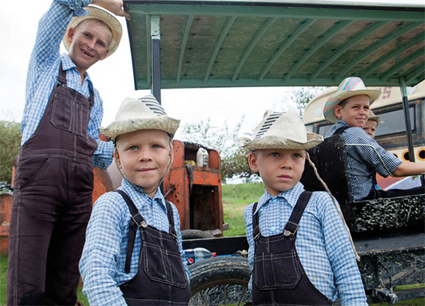
The road from Orange Walk to Blue Creek was settled by mestizos and Yucatec Maya fleeing the Mexican Caste Wars, and many villages still bear Maya names like Yo Creek and Chan Pine Ridge. In the 1950s they were joined by a new immigrant group: the Mennonites (see box), who have ended up in two settlements, each representing opposite ends of their philosophical spectrum. The most conservative sect lives in Shipyard $ [map] . Known as the Old Colony, this is where the Mennonite women wear long, dark dresses and large beribboned straw hats in a style brought from Europe, while taciturn men wear suspenders or overalls rather than belts.
Along the Río Bravo escarpment in northwestern Orange Walk District is the more progressive Mennonite community of Blue Creek Village % [map] .
Río Bravo Conservation & Management Area
In the far reaches of northwest of Orange Walk District is the Río Bravo Conservation and Management Area ^ [map] , established by the Program for Belize, which was founded in 1988 by the Massachusetts Audubon Society. This enormous tract of land – about 121,000 hectares (300,000 acres) – is designated for research and conservation, and is held up as one of Belize’s most successful environmental conservation projects. The lands were acquired through donations inspired by its distinctive ‘sponsor an acre of rainforest’ fund-raising appeal.

Mennonite boys in Orange Walk district.
Shutterstock
With more than 240 species of trees, 390 species of birds, and over 70 known species of mammal, Río Bravo represents one of Belize’s highest concentrations of biodiversity. To generate further income, the program has entered the ecotourism industry and offers on-site accommodations and meals at two field stations: La Milpa and Hill Bank, located at opposite ends of the reserve.
Accommodations include cabañas and ‘green dormitories’ near La Milpa (5km/3 miles from the ruins) and Hill Bank field stations. For reservations, contact www.pfbelize.org.
Chan Chich Lodge and Gallon Jug
Just south of the Río Bravo Area lies the Gallon Jug & [map] , a parcel of land covering some 52,000 hectares (130,000 acres) of tropical forest retained by Barry Bowen as a private preserve. Intensive farming is carried out in a small area, with corn, soybeans, coffee, cacao, and cardamom being grown. But Gallon Jug is best known for the spectacular Chan Chich Lodge (www.chanchich.com), which is located – with the Archeology Department’s blessing – in the lower plaza of an ancient Maya site. Chan Chich Lodge was carefully planned to have a minimum impact on the surrounding tropical forest and the Maya plaza (it also protects the site from robbers). It features luxurious thatched cabañas and a cozy dining room and bar, paneled in a variety of local hardwoods. There is also a screened swimming pool and Jacuzzi.
As a private preserve protected from hunting, Chan Chich enjoys some of the most abundant concentrations of tropical forest wildlife in Central America. Various tame animals wander around the site, including deer and foxes; there is a wealth of birdlife and jaguar sightings are not uncommon.