LA BORN, SALVADOR RAISED
While the criminal gang Mara Salvatrucha, or MS-13, originated in Los Angeles, California, the majority of its members are ethnic Salvadorans. National Geographic went as far as to call them the World’s Most Dangerous Gang in a 2005 documentary. They have expanded across urban areas of North America and their reach goes as far as Australia. Named after guerrilla fighters during the Salvadoran Civil War, the gang is so large, with 30,000 to 50,000 members worldwide, that it has its own subculture of sorts, with members speaking in their own form of sign language. The most popular hand sign, learned from heavy metal concerts, is the ‘devil’s head’ which, when displayed upside down, forms an ‘M.’ Tattoos are a distinguishing element of most MS-13 members, who often cover their bodies and sometimes faces, although it’s believed some members are moving away from the trait in the attempt to go unnoticed.
The gang is known for their violent ways and connection to the drug trade and sex trafficking, which has caused increased concern in the US, where stepped up immigration efforts have pushed for more members – as well as those who have minor associations with them – to be deported to El Salvador. The thousands of MS-13 members returning to the country in recent years has led to higher crime rates and instability in El Salvador’s urban areas.
Western El Salvador
Moving west from San Salvador, the landscape transitions from the hot, flat plateau to a more scenic, mountainous terrain lined with coffee plantations and charming rural villages. Along the Ruta de las Flores, artisan towns with cobblestone streets and perfectly manicured gardens make for a quick escape from the heat of the capital. Closer to the Guatemalan border, the landscape gets more rugged, with jungle-clad hillsides and what many claim is the country’s best national park, aptly named El Imposible.
Santa Ana
Sixty-five km (40 miles) west of San Salvador is the country’s second largest city, Santa Ana 3 [map] . With its tree-lined streets and air of general order that seems lacking in the capital, many travelers prefer to base themselves here and take day trips to nearby attractions like the Tazumal ruins or the Ruta de las Flores.
Coffee wealth in the early 20th-century helped fund a building boom in the city, with barons building haciendas in the surrounding hills and some of the country’s best architecture within a few blocks of the main plaza, Parque Libertad. The neo-Gothic Cathedral, completed in 1913, is the most imposing monument, while the neo-colonial Teatro de Santa Ana has frequent performing art performances, some of which are free. While coffee is still important here, the city’s economy primarily revolves around the foreign-owned factories in the north of the city.
South of town is Lago Coatepeque, a deep blue crater lake surrounded by forests and the mansions of the wealthy. Most of the lakeshore is privately owned and inaccessible aside from a small public section that is lined with restaurants and small hotels, many of which rent kayaks and other watercraft.
Tazumal and Casa Blanca
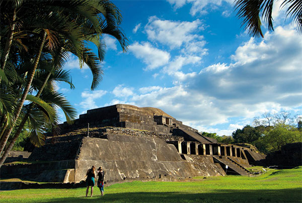
El Salvador’s most important Mayan ruin is Tazumal 4 [map] (Tue–Sun), 13km (8 miles) west of Santa Ana. Mostly excavated, the ruins cover 10 sq km (4 sq miles), encompassing a pyramid, ball court, and other examples of classic Mayan architecture. Believed to be an important trading center, Tazumal, which translates to ‘the place where the victims were burned,’ dates as far back as AD 100. It’s believed that construction at the site was abandoned for many years after an eruption of the Ilopango volcano, though picked up again in the Early to Middle Classic period from AD 250–650 until about AD 1200. Artifacts in the small site museum reveal that the city has contacts with communities as far away as southern Mexico. Nauhtl Tours (www.nahuatours.com) runs day trips here, though the site can easily be visited with private transportation and will take about an hour to explore.
A little more than 1km (0.6 mile) north, on the other side of the town of Chalchuapa, is the archeological site of Casa Blanca (Tue–Sun 9am–4pm). There are several Maya Late Preclassic and Classic pyramids and other structures. There’s a small site museum and, more interesting, an indigo dye workshop.
Los Volcanoes National Park
Within the Apaneca-Llamatepec Biosphere Reserve, Los Volcanoes National Park 5 [map] , aka Cerro Verde National Park, is home to three volcanoes: Iazalcom, Santa Ana, and Cerro Verde. The park, just southwest of Lago de Coatepeque, is filled with lush cloud and tropical forests and is a hotspot for migrating bird species. Emerald toucanets and numerous species of hummingbirds can easily be seen on a short hike from the visitor center at Cerro Verde, located in the center of the park. From the visitor center, there are four-hour round-trip hikes to the summits of either Volcán de Izalco or Volcán Santa Ana, the latter one of the most active volcanoes in El Salvador and the second highest peak. Both hikes are steep, challenging climbs up a barren landscape and leave once per day with a guide (who works for tips) from the parking lot at 11am.

Tazumal’s ruins.
Getty Images
Fact
In the early 20th century, a collapse in the price of coffee lead to an uprising of mostly Nahuatl coffee farmers along the Ruta de las Flores. On January 22, 1932, government forces stepped in to suppress the rebellion and an estimated 30,000 were killed in the aftermath. The event became known as the Peasant Massacre.
Ruta de las Flores
West of San Salvador along Highway CA-8 is a 36km (22-mile) stretch of scenic roads known as the Salvador Ruta de las Flores, or Route of the Flowers, which connects a string of quaint mountain villages.
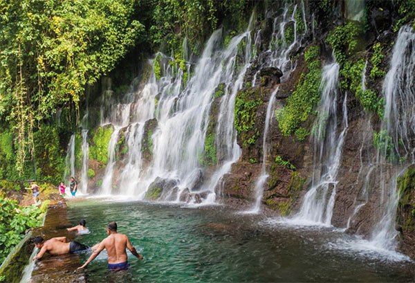
The first village on the route is Nahuizalco best known for its hand-crafted furniture. The most visited village, Juayúa 6 [map] , pronounced ‘why-ooh-ah,’ features cobblestone streets and a renowned black Christ statue carved by Quirio Cataño in the late 16th century. Originally a Nahuatl settlement, Juayúa was the epicenter of Indigenous uprisings in the region in 1932, which were quickly put down by government forces backed by the coffee barons. Los Chorros de la Calera, a natural area with waterfalls and a swimming hole just outside of town, is a popular distraction in the summer.
At 1,450 meters (4,757ft), Apaneca is El Salvador’s second highest town and is a base for hiking in the surrounding Sierra Apaneca Ilamatepec mountains. With a more authentic feel than Juayúa, the colorful adobe houses and handicraft shops seem surprisingly undiscovered by day trippers from San Salvador. While Iglesia San Andres was mostly destroyed in a 2001 earthquake, it has been rebuilt. Just south of town is Finca Santa Leticia (www.hotelsantaleticia.com), a hotel and coffee farm with a small archeological park.
At Ataco, the adobe walls are splashed with brightly colored murals that blend Indigenous and contemporary styles. The town has seen an influx of unique stores and cafés in recent years, giving it something of a bohemian feel. Located near the Guatemalan border, Ahuachapán is the birthplace of Salvadoran poet Alfredo Espino and a good base for hikes in El Imposible National Park.

Bathing in Los Chorros de la Calera waterfalls.
Shutterstock