Fact
Momostenango means ‘Citadel of the Altars,’ after the many altars found around the town and surrounding hills and reflecting the longstanding religious devotion of many of the townspeople.
Unfortunately, Zaculeu was insensitively rebuilt in 1947, the temples covered in a bland stucco finish, lacking any decorative detail. Despite this, it is still worth a visit – the ruins sit above ravines on three sides, providing tremendous views, and there’s also a small museum on site with exhibits of burial pieces (daily 8am–noon, 1–6pm).
Todos Santos Cuchumatán
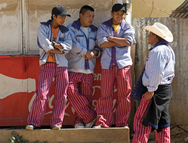
Todos Santos Cuchumatán * [map] , some 50km (31 miles) northwest of Huehue, is famous for its spectacular festival (see box), in addition to its sublime setting in a canyon-like valley beneath the 3,837-meter (12,589ft) peak of Chemal, and richly colorful evidence of Mam Maya culture throughout town. The women wear beautiful purple and navy huipiles that are among the most tightly woven in the country, but it is the men who are the real peacocks – they sport an almost outrageous outfit of candy-striped pants and thick cotton shirts with huge, flapping pink or purple collars.

Men wearing the distinctive costume of Todos Santos Cuchumatán.
Corrie Wingate/Apa Publications
The countryside around Todos Santos is perfect for challenging hikes, including one route that takes you out of town, south past the minor ruins of Tojcunanchén, up on to the spine of the Cuchumatanes and on to the equally traditional Mam village of San Juan Atitlán, six hours’ walk away. A variety of top-notch local guides offer guided treks from Todos Santos – ask at your lodging for recommendations and contact information. Todos Santos also has a couple of popular language schools, including Academia Hispano Maya (www.hispanomaya.weebly.com).
The Pacific Coast
Glance at a map of Guatemala, and the 300km (190-mile) long Pacific coastline might appear to be the perfect place to chill out. But if you are dreaming of palm-fringed beach resorts, try the Caribbean. Guatemala’s Pacific coast is the engine room of its agricultural economy, a sultry, humid strip of land that’s almost entirely dominated by vast fincas devoted to sugar cane, cattle ranching, cotton, and bananas.
Attractions in this area are thin on the ground, but there are a few highlights: between the sugar plantations are important (both Maya and Olmec) archeological remains at Takalik Abaj and in numerous sites around the town of Santa Lucía Cotzumalguapa, including the colossal stone heads in La Democracia. The scale of these sites cannot compete with the temples and pyramids of the Petén and Yucatán, but some of the sculpture is fascinating.
Running parallel to the coast is Guatemala’s fastest highway, the Carretera del Pacífico, and it is simple to get around this route by bus. To explore the region fully, however, you will need your own transportation, as many of the sights, and all the beaches, are a considerable distance off the highway.
Monterrico and around
The village of Monterrico ( [map] is a popular base for exploring the coast, with a few casual beachfront hotels and access to the surrounding wetlands, which are protected as part of a national nature preserve, the Biotopo Monterrico-Hawaii. The preserve forms an important habitat for herons, egrets, and migratory birds, iguana, alligators, opossums, raccoons, and anteaters. It is the three species of sea turtles that nest on these shores that make Monterrico really special, however.
Retalhuleu and Takalik Abaj
Retalhuleu ‚ [map] , usually shortened to ‘Reu’ (pronounced ‘RAY-oo’), draws in visitors with its attractive, shady plaza, a relaxed air, and a good Museo de Arqueología y Etnología (Tue–Sat 9am–noon & 2–5pm), which is full of historical photographs and anthropomorphic figurines. West of Reu, near the small village of El Asintal, is Takalik Abaj ⁄ [map] (daily 7am–5pm), probably the most important ruins on the entire coast, with Maya and Olmec-style temples as well as stelae and altars, and a small but worthwhile museum.
Eastern Guatemala
This varied region has some superb lakes, the wonderful carved stelae of Quiriguá and Copán, a quetzal preserve, and a fascinating Caribbean coastal culture. A network of protected preserves has been established to safeguard the region’s ecosystems, and the unique habitat of species like the manatee and the quetzal, the national bird – but this preserve status is all too often poorly enforced.
Historically, the Motagua River that flows through the heart of the region to the Caribbean Sea was a crucial trade route. Close to the banks of the Motagua were the largest jade deposits in the entire Maya area, contested and controlled by the Maya settlements of Quiriguá and Copán. Today the ruins of both sites are essential visits for their astonishing sculptural remains.
The Verapaces and Salamá
The twin departments of Baja and Alta Verapaz (vera paz meaning ‘true peace’) were the last part of Guatemala to fall under Spanish control (apart from Flores), such was the ferocity of opposition from the Indigenous Achi tribes, and dominance was only established in 1538 after a successful ‘softly-softly’ approach pioneered by a group of Dominican priests led by Fray Bartolomé de las Casas.