El Imposible National Park
The 3,800-hectare (9,400-acre) El Imposible National Park 7 [map] , the largest in El Salvador, was named for a dangerous gorge that often claimed the life of farmers transporting coffee to the Pacific. The birthplace of eight rivers and home to extensive rare tropical dry forest, the park ranges in altitude from 250 meters (820ft) to 1,425 meters (4,675ft), allowing for a stunning array of flora and fauna, including pumas, wild boars, and nearly 300 species of birds. You can enter near the town of Tacuba, which has basic accommodations. From here trails lead into the green hills, past waterfalls and caves etched with Pre-Colombian petroglyphs. All visitors must first register with park administrator in San Salvador and, because independent hiking is not allowed within the park, organise a guide. This is all best done through an established local tour operator.
Northern El Salvador
North of San Salvador the hills become mountains, hiding former rebel villages that are now prime tourist attractions. One the shores of Lago de Suchitlán, one of the country’s top bird-watching spots, is the attractive art-centric village of Suchitoto, surrounded by forests, volcanoes and a large lake, making this the preferred base for hikes and other outdoor activities. Handicraft centers like Concepción de Quezaltepeque and La Palma are here, as is Cerro El Pital, El Salvador’s highest peak, and the cloud forest of Montecristo National Park.
Suchitoto
Often called just Suchi, Suchitoto 8 [map] is a former rebel village that has become the preeminent tourist destination in the northern reaches of the country. Overlooking Suchitlán lake, Suchitoto has a vibrant history, having briefly been the capital of the country and a focal point of the civil war. Still, the colonial city has escaped the natural disasters of other cities, with its well-preserved white-washed houses and cobblestone streets.
Fact
During El Salvador’s brutal, 12-year long civil war, rebel soldiers often spent much of their time in tatús, cave hideouts scattered around the rugged terrain in the north and east of the country, similar to what the Viet Cong created in Vietnam. Within these bunkers, safe from bombs and enemy fire, the rebels built hospitals and even a radio station that was broadcast around the country.
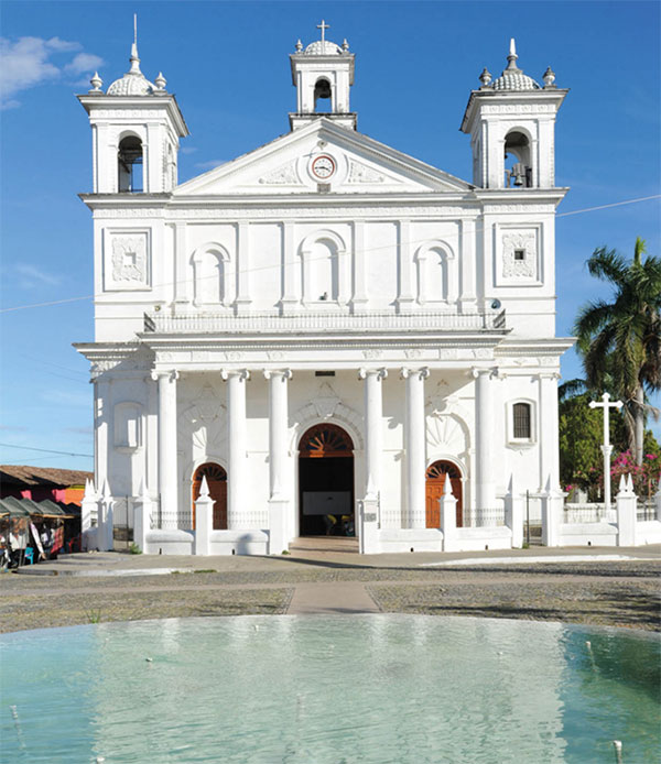
Plaza Centenaria, the city’s main plaza, and the surrounding blocks are where much of the finest architecture can be found. The post-colonial Santa Lucía Church (daily 8am–noon and 1–6pm), built in 1853, is topped with three towers and features a facade with molded arches and six columns. Several of the centuries-old buildings have been turned into boutique hotels, such as Los Almendros de San Lorenzo (www.losalmendrosdesanlorenzo.com), with corridors lined with original wood columns and a fresco by Salvadoran master painter Luis Lazo.

Santa Lucía Church, Suchitoto.
iStock
To the west, the Centro Arte para La Paz (www.capsuchitoto.org; hours vary; free), opened in 2000 in a former Dominican convent, is a gallery and museum that donates proceeds to victims of domestic violence. It’s a hub of cultural activity in the city. Nearby is the gallery of Argentine sculptor Miguel Martino, known as Casa del Sculptor (tel: 2335 1836; www.miguelmartino.net; Sat–Sun 9am–5pm; free), which holds feasts for guests every Sunday from noon–4.30pm, utilizing his wood fired grill and lots of Argentine wine.
Tip
Founded by renowned cinematographer and Suchitoto resident Don Alejandro Cotto several decades ago, Suchitoto’s International Permanent Festival of Art and Culture is held on weekends throughout February. Fine arts performances from national and international artists take place at venues around town for the duration of the festival.
On the road to the lake is the Casa-Museo Don Alejandro Cotto (Tue–Sun 9.30am–5pm), the former home of the Salvadoran filmmaker and writer of the same name. The house, with its spectacular views of the lake, acts as something of a city museum, displaying Suchitoto’s cultural history, as well as boasting an extensive network of gardens and trails.
Outside of Suchitoto
A short walk to the east of the center is Los Tercios, a 9-meter (29.5ft) high waterfall and swimming hole. The face of the falls are made up of nearly uniform vertical rocks, believed to have been created from lava that cooled very rapidly, which are covered in moss. On weekends vendors come here to sell pupusas and drinks.

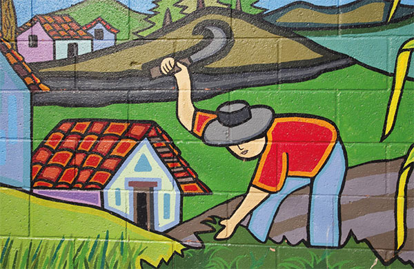
Detail of a La Palma, wall painting.
Alamy
On the lakefront at Puerto San Juan, there is a public swimming pool and a few traditional restaurants that fill up on weekends. Boats line up here to sell tours of the 135-sq-km (52-sq-mile), man-made Lago Suchitlán, which was created in 1973 when the government dammed the Río Lempa. Most of the tours stop at La Isla de los Pájaros, a resting point for the many migrating birds that pass through here.
About an hour east of Suchitoto is the tiny village of Cinquera, where the bullets and bomb damage have been preserved to showcase the rebel town’s history. Murals around the main plaza depict the war and the tail of a downed government helicopter sits on display. A 4,000-hecatre (9,884-acre) ecological park outside the town is open daily and has a small network of trails and a waterfall that are worth exploring on a day visit.
Concepción de Quezaltepeque
North of the lake, opposite Suchitoto, the landscape is made up of rugged hills dotted with patches of dry forest and farmland. The civil war impacted this area hard and a cave network that once housed rebel hospitals and even a radio station can still be seen. Many come to this region to visit the village of Concepción de Quezaltepeque, which is devoted to the production of colorful hammocks. Nearly the entire town is involved in the hamaca industry in some form, either weaving the tapestries that hang from them or selling the final product in the stores that surround the main plaza. The town gets busiest on weekends, when hammock sales are in full swing and there’s a festival-like atmosphere.
La Palma
High on the mountainside, 50km (31 miles) west of Chalatenango, the remote village of La Palma 9 [map] is best known for its murals, created and influenced by renowned artist Fernando Llort, who moved to the village in 1972. The naïve-style murals of religious figures and mountain villages are noted for their colorful, geometric designs. Before moving away, Llort taught local residents to paint in much the same way and La Palma has become a driving force in the modern Salvadoran art movement. The murals cover the galleries along the center of town. Llort’s cooperative, La Semilla de Dios, is open daily and is where many of the town’s artists can be found at work.
About 30-minutes outside of La Palma is El Salvador’s highest peak, Cerro El Pital, which rises to 2,730m (8,957ft) above sea level. The road takes visitors most of the way up to the summit, with only a two to three hour round-trip hike required. One stretch of the trail is privately owned, and someone will usually ask for a small fee to pass.