Volcanoes
With more than 100 large volcanoes, Central America is one of the most active volcanic zones in the western hemisphere. The Sierra Madre in the southern Mexican state of Chiapas marks the beginning of a long volcanic chain that stretches down along the Pacific coast. Forming the backbone of the Central American isthmus, this rugged range of mountains and volcanic peaks cuts a swathe through the land of the Maya, dividing it into highlands and tropical lowlands with just two major interoceanic passes at the mouth of the San Juan River to Lake Nicaragua and along what is now the Panama Canal. The rich volcanic soils, fed by ash spewed out millions of years ago, also proved perfect for growing crops like coffee, which have helped shape Central American history and society since the late 19th century.
In Costa Rica’s Central Valley, Poás Volcano, at 2,700 meters (8,900ft), has one of the world’s largest craters, measuring nearly 2km (1.5 miles) in diameter.
Many of the region’s volcanoes are concentrated in the Guatemalan highlands, where there are 33 volcanoes, which are mostly inactive or dormant. Several do remain active, however, such as Volcán Pacaya, which has been in an almost constant state of eruption since 1965. This activity ranges from minor gaseous emissions and gentle steam eruptions to explosions so powerful as to hurl ‘bombs’ up to 12km (7.5 miles) into the air. Although such serious outbursts are rare, Pacaya – which looms over the south of Guatemala City – does emit regular lava flows, and an ashy pall often hangs over the immediate area. Occasionally local villages need to be evacuated. The last major volcanic eruption in Guatemala occurred in March 2018 when 201 people were killed when Fuego erupted.
Biodiversity
This central mountain range that runs down the funnel shaped land mass and the proximity of the two coasts help contribute to Central America’s vast array of microclimates, which are the primary factor in the immense biodiversity found here. As you travel around Central America, you’ll notice how drastically the landscape changes, even within a short distance. Each region has its own ecological characteristics.
Across much of the region’s lowlands, the climate is wet and warm enough for trees to keep growing for much of the year. The result of this nonstop growth is generally called rainforest. Strictly speaking, though, botanists restrict use of this term to the wettest forests of all. Unlike the trees in tropical dry forests, rainforest trees are evergreen, and their dense crowns form a continuous canopy that casts a deep and almost unbroken shade. These rainforests – both on low ground and at higher altitudes – harbor an immense variety of life. While they only cover 2 percent or so of the total surface area of the Earth, rainforests harbor roughly 50 percent of all flora and fauna on the planet.
In the drier parts of Central America, where little rain falls for four or five months of the year, the natural vegetation is dry tropical forest, with most trees shedding their leaves soon after the dry season begins. The trees are rarely more than 30 meters (98ft) high, and there is usually a tangled understory of spiny and thorny shrubs. Although the trees are leafless during the dry season, few of them are fully dormant, and many burst into flower soon after their leaves have been shed. Patches of dry forest can be found in southeastern Mexico, Guatemala, El Salvador, Nicaragua, and Costa Rica.
On the low-lying coasts of Central America, mangroves are the natural vegetation, and they form extensive forests on both the Caribbean and Pacific shores. These ecoregions are important nesting sites for many bird species and also provide a habitat for fauna like monkeys, caimans, and pumas.

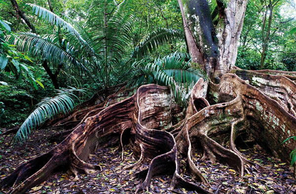
Giant buttress roots on a rainforest tree at Hacienda Baru, Costa Rica.
GREAT BALLS OF FIRE
The highest peaks in the cordillera are Guatemala’s Volcán Tajumulco and Volcán Tacaná, which rise above 4,000 metres (13,123ft). Additionally, there are 35 other peaks that stand at 2,000m (6,562ft) high, scattered about the region in every country except Belize. On the highest peaks of the cordillera, the forest gives way to a treeless landscape known as páramo. Cold and frequently swathed in cloud, páramo seems a world away from the warmth and lushness of lower altitudes. This ecosystem is dominated by tough, low-growing shrubs that can withstand strong winds. Páramo is found in patches in Guatemala, Costa Rica and Panama.
The region’s coastlines are home to extensive beaches – often of dark volcanic sand – punctuated by low-lying rocks and a small number of offshore islands. The Mesoamerican Barrier Reef System stretches over 1,000km (621 miles) from Isla Contoy off the top of the Yucatán Peninsula down to the Bay Islands. Smaller reefs can be found along both coasts. Reef-building corals need sunlight to grow, and they can only survive in clear water. This limits them to areas well away from the mouths of silt-laden rivers, but it also makes them vulnerable to any increase in silt run-off. The longest rivers of Central America flow to the Caribbean, though some smaller ones drain into the Pacific. Additionally, there are three large lakes: Lake Nicaragua and Lake Managua in Nicaragua and Gatún Lake in Panama, which forms part of the Panama Canal.
Environmental protection
Despite accounting for only 0.1 percent of the Earth’s surface, Central America boasts 7 percent of the world’s biodiversity. While the region’s enormous collection of flora and fauna is impressive, much of it is threatened. More than 100 species are classified as critically endangered, plus another 200 or so that are threatened. In recent history, money has taken precedence over conservation and forests have been chopped down to make room for cattle. The soil has been depleted and a wide range of rare habitats have been destroyed. Deforestation and rainforest fragmentation is a major concern and an estimated 80 percent of the vegetation in Central America has already been converted to agriculture. While economically important, tourism, mining, and farming have taken a toll on the environment. There is some hope, however.

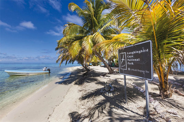
Tropical beach at Laughingbird Caye National Park, Belize.
National parks, biological preserves, wildlife refuges and other categories of protected areas, both private and public, now cover significant portions of many Central American nations. More than 25 percent of several nations in the region have been set aside in some form or another by human beings to protect it from the potential exploitation and ravages of other human beings. Over 36 percent of all land territory in Belize has some form of protected status, which is more than anywhere else in the Americas. Additionally, countries such as Panama and Honduras have maintained at least 40 percent of their forest cover. In Costa Rica 51 percent of the land remains forested (although 23.9 percent is considered primary forest cover).
Marine territory is also under threat around Central America. The region’s network of coastal wetlands, lagoons and mangroves supports nearly 60 types of coral like brain and elkhorn, 350 mollusk, and 500 fish species. The Mesoamerican Barrier Reef System, extending from Mexico to Honduras, is one of the most diverse ecosystems on earth and only around 10 percent of all species here have been discovered. While healthy marine ecosystems support tourism, overfishing, pollution, invasive species like lionfish, and changing coastlines endanger much of it, not to mention the effects of climate change. But NGOs are working with local governments to find solutions such as no-take zones for fish stocking.