BELIZE: THE PATH TO INDEPENDENCE
It took Belize many years to win its independence. After the decline of the Maya settlements in Belize, it was British settlers – known as ‘Baymen’ – and their slaves from the Caribbean who began to occupy the territory in the 17th century. These new inhabitants were interested above all in the lumber to be found in Belize’s forests, and they founded the first settlement on St George’s Caye, a small island off the southern coast.
Relations with the Spanish rulers of neighboring Guatemala were frequently tense throughout the 17th and 18th centuries, as British pirate ships used Belize’s sheltered waters as harbors from which to attack Spanish ships. As a result of the American War of Independence, Spain declared war on Britain and in 1779 a sizeable Spanish force attacked St George’s Caye. The settlement was rebuilt, but in 1798 the Spanish attacked again. Despite the fact that the Spanish force had far superior firepower, a decisive sea battle was fought at St George’s Caye, and the Spanish were soundly defeated. In 1862, Britain finally recognized Belize as the Colony of British Honduras, and in 1871 it became a Crown Colony. And, in 1992 the Guatemalan Congress officially ratified the decision to recognize Belize, which led to a final pull-out of the British garrison in 1993. The struggle within Belize to gain independence from Britain began in earnest after World War II. The People’s United Party (PUP), under leader George Price, was founded in 1950, and in 1961 George Price became the colony’s First Minister.
On October 31, 1961, Belize was devastated by Hurricane Hattie. This particularly affected Belize City, which had been the capital since the 18th century. The authorities decided to build a new inland capital: Belmopan, named in honor of the Mopa, the Maya tribe who had resisted the Spanish conquistadors, and ‘Bel’ for Belize. Belmopan soon became a symbol of the new, independent Belize, though it has struggled over the years to evolve from an administrative center to a thriving city.
The long-sought independence from Britain was won in 1981, and George Price was elected the first prime minister of the newly independent country.
Hidden Valley Falls are also known as the ‘Thousand Foot Falls,’ although they happen to be 480 meters (1,600ft) high. From the picnic ground you can watch the thin plume of water stream down a cliffside and disappear into the lush forest below. In the vicinity are many smaller but arguably more beautiful falls, including Big Rock Falls and perhaps the most charming, Butterfly Falls. Eighteen kilometers (11 miles) farther southwest (marked on the left) are the Río On Pools, natural rock pools and little waterfalls formed by enormous granite boulders, in a serene open setting – also ideal for a swim. Eight kilometers (5 miles) south is the turn off to the Río Frío Cave fi [map] , the largest cave in Belize and the most accessible. During the dry season, it is possible to follow the river into the cave’s enormous mouth and out the other end. The rocks are a little slippery, but not unmanageable; inside are unusually colored rock formations, stalactites, and the odd colony of bats. There is also a 45-minute outdoor nature trail for the energetic.

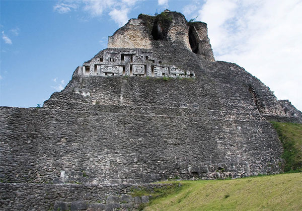
El Castillo at Xunantunich.
Corrie Wingate/Apa Publications
A variety of accommodations have been set up in the area, including Blancaneaux (www.thefamilycoppolahideaways.com), a luxury lodge and resort owned by the Hollywood film director Francis Ford Coppola.
Xunantunich
San José Succotz, a village a few km/miles southwest of San Ignacio, is the jumping-off point for the Maya ruins of Xunantunich fl [map] (daily 8am–4pm), one of the biggest attractions in the Cayo District, and one of the most impressive Maya sites in all Belize. The ruins are reached by crossing the Mopan River on a hand-winched ferry. In contrast to Cahal Pech, the Maya site of Xunantunich is inspiring, and the view from the top of the highest structure is breathtaking. The view of the Mopan River from the ferry on the way over is itself memorable. Xunantunich is best known for the towering pyramid known as El Castillo, or A-6. At around 40 meters (130ft), this was considered the highest structure in Belize until the pyramid at Caracol was found to top it by a few feet. In 2016, a great Maya treasure was discovered at Xunantunich: one of the largest royal tombs ever found in the country. The burial chamber revealed a male corpse, as well as jade, animal bones and ceramic vessels.
Caracol
The main attraction for most travelers in the Chiquibul Forest Reserve and National Park is the ruined Maya city of Caracol ‡ [map] (daily 8am–5pm). Until 1993, Caracol was only accessible by one of the worst roads in Belize, but a paved highway cut the driving time down to two hours. Even so, the going can be rough, particularly when it rains. The route runs into the Vaca Plateau, with a return from pines to the more familiar rainforest foliage and some spectacular views over mountains and river valleys.
Beneath the Vaca Plateau are a series of great cave complexes, including the Chiquibul, which may be the largest in the western hemisphere. It was only found by modern spelunkers in the 1970s and remains little explored – although tales of prehistoric fossils being discovered there have sparked interest. The road becomes progressively more bone-shaking until the ruins suddenly appear – a Maya pyramid, hacked from the jungle, glimpsed through a gap in the vines.